Tuesday, February 28, 2006

Palaeolandsurface Identified

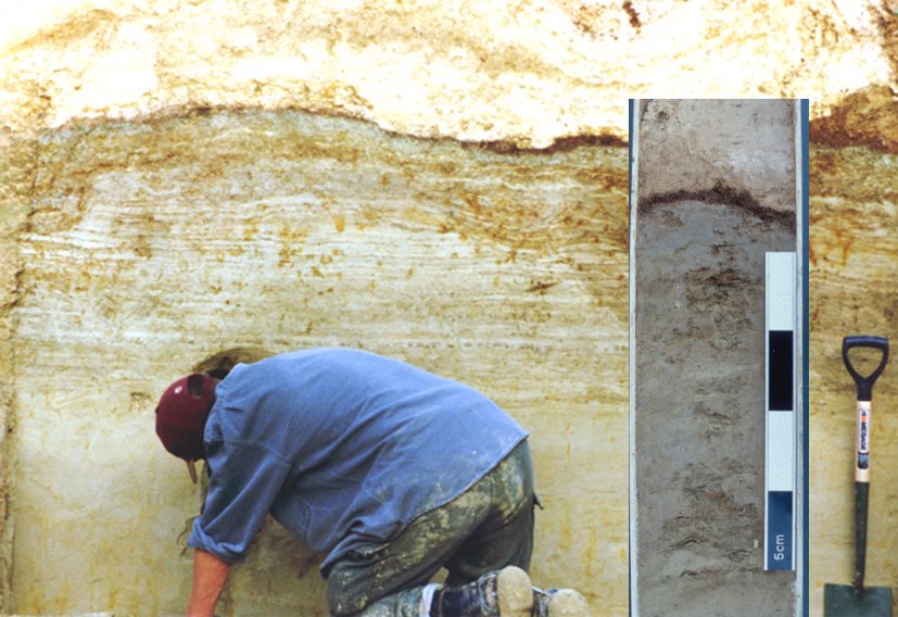
In line with expectations, the Boxgrove palaeolandsurface has been located in the Northern part of the Quarry, an area potentially under threat during the new phase of extraction. These sediments are identical to those which have produced in-situ archaeology, human remains and butchered animals carcasses dating to over half a million years old at Boxgrove.Now that this key horizon has been identified surviving within the Valdoe Quarry a plan can begin to be formulated to mitigate against any extraction work which impacts upon it.

Extraction of the old Haul Road begins

There are two areas within the Valdoe Quarry where renewed extraction may impact upon the Boxgrove palaeolandscape. One lies beneath the old north-south haul road which cuts through the eastern part of the quarry.This week the first phase of extraction began here, removing the overlying decalcified gravels, or Hoggin, and exposing the underlying calcareous coombe rock. Within the next few weeks it should be possible to determine the actual distribution of the landsurface within this area.

Sunday, February 26, 2006

Valdoe Assessment Survey begins


The Valdoe Quarry lies on the Goowood Estate, near Chichester in West Susssex. Topographically it occupies an almost identical position to the Boxgrove sites although it lies some 6km to the west. Between 2001 and 2003 the Raised Beach Mapping Project identified the presence of archaeologically sensitive deposits across the Goodwood Estate identical to those preserving half million year old bucthery sites and human remains at Boxgrove.

Throughout 2006 a new project, funded by DEFRA through the Aggregates Levy Sustainability Fund, has been established to determine the full extent of the palaeolandsurfaces within the vicinity of the Quarry, to determine the degree to which the Quarry has impacted upon the these deposits and to develop a plan for future mitigation should Quarry work begin to impact upon surviving areas of palaeolandsurface.

The Project, which commence in Jan 2006, represents a unique level of cooperation in Sussex between the Goodwood Estate, Dudmans, West Sussex County Council, English Heritage and DEFRA through the ALSF. Over the course of the project the latest news and results can be followed here.

Saturday, February 18, 2006

Boreholing Phase Commences

In order to determine the presence of the Boxgrove palaeolandsurface within the threatened areas of the Quarry a series of boreholes will be sunk this week to map the subsurface geology. A team from West Wight Drilling have been hired to undertake this work using a standard Dando percussion rig. 5-6 boreholes should be all that is required to create, when combined with exisiting data sets, a local geological model of the area.